Nephrops (Nephrops norvegicus), more commonly called langoustines, Dublin Bay prawns or just prawns, are a commercially important shellfish species, with numerous fisheries around Great Britain and Ireland. The fisheries represent an economic value of £114 million (UK Sea Fisheries Statistics 2023) per annum to the UK and £53 million to Ireland (€61 million Fisheries Overview | Marine Institute 2023) and are a vital source of income for coastal communities and associated industries.
Underwater Television (UWTV) surveys have formed the basis of assessing the status of Nephrops stocks since the 1990s. Despite significant technological developments over the same period, the basic process for carrying out these surveys has remained largely unchanged to the present day.
UWTV surveys were originally developed in the 1980s by the Department of Agriculture and Fisheries for Scotland (DAFS), with their first survey carried out by the then newly created Fisheries Research Services (FRS) in 1992, continuing ever since and now being carried out by Marine Scotland. Cefas conducted its first UWTV survey in 1996. The Marine Institute (MI), in the Republic of Ireland, commenced in 2002, shortly followed by the Agri-Food and Biosciences Institute (AFBI), Northern Ireland, in 2003 and the approach has continued to be adopted by other institutes. Today, well over 20 discrete Nephrops fisheries areas from Iceland and Scandinavia down to the Bay of Biscay and Mediterranean are regularly surveyed using UWTV methods.
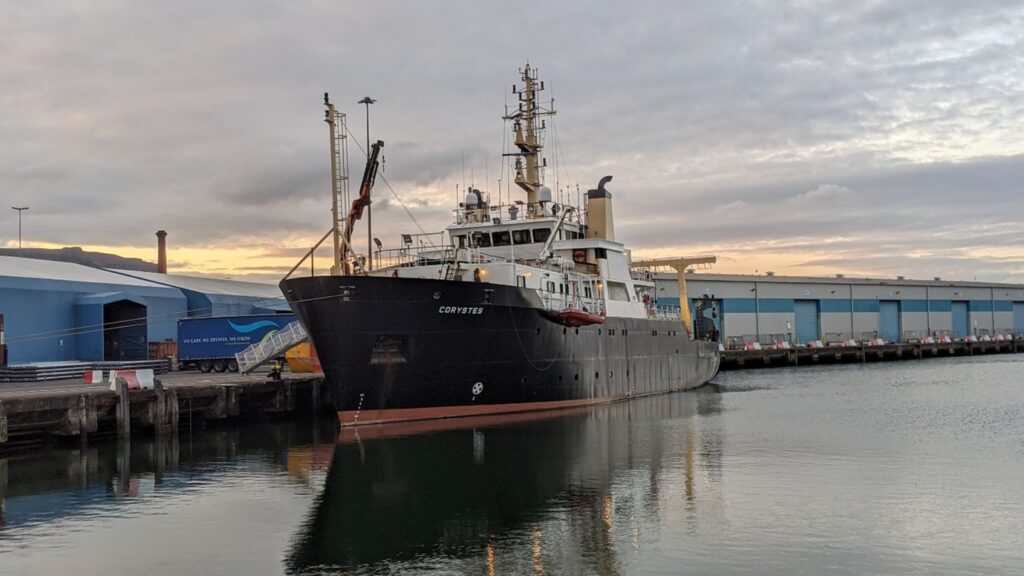
The Research Vessel (RV) Corystes is a research vessel with a distinguished legacy in marine science. Over more than four decades, she has played an important role in supporting marine and fisheries research, contributing to our understanding of the marine environment. She has been conducting UWTV surveys since 1996, firstly for Cefas, then, from 2006 for the AFBI in Northern Ireland. AFBI continue to lead and co-ordinate joint surveys, currently conducted in collaboration with scientists from Cefas and the Marine Institute. Together, these three organisations work together aboard the Corystes towards a common goal: to estimate the number of Nephrops in the two main fishing areas of the Irish Sea. This close exchange of expertise and experience is central to the success of the surveys, supporting accurate and consistent assessments across both fishing areas.
This collaboration continues, even when the survey is finished. Scientists from AFBI, Cefas and MI work alongside other European scientists at the International Council for the Exploration of the Sea (ICES), where survey methods, results and associated stock assessments are scrutinised and reviewed, to ensure consistency of approach. This allows the delivery of robust scientific advice to assist policy makers in the UK, EU and elsewhere in Europe in managing their Nephrops fisheries.
Underwater Television surveys
So, what goes into a Nephrops survey and processing of data collected?
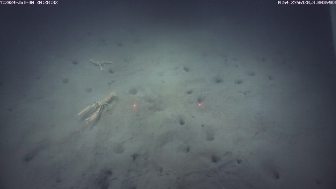
The first step is identifying where to survey. Fortunately, this is relatively straight-forward for Nephrops. Nephrops are burrowing decapod crustaceans, belonging to the same taxonomic (scientific) family as larger European lobsters. Much like many terrestrial animals, they excavate and spend much of their lives in burrows, emerging only to forage for food and find a mate. Unlike European lobsters which prefer rockier habitats, Nephrops prefer softer sediment types to construct their burrows, typically in mud or muddy sand. Based on a combination of survey work to identify the sediment type and using fishing activity data, we can characterise the areas where the Nephrops are most likely to live and then survey those locations.
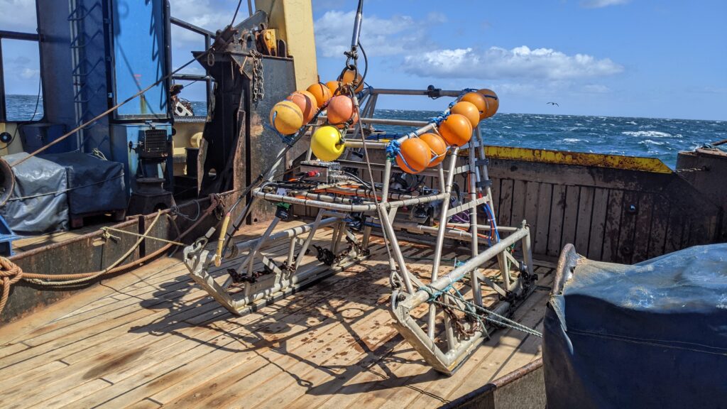
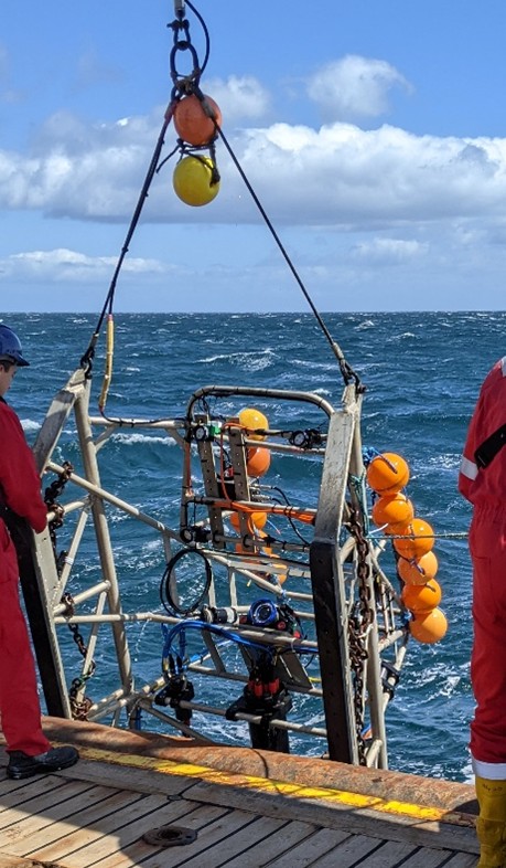
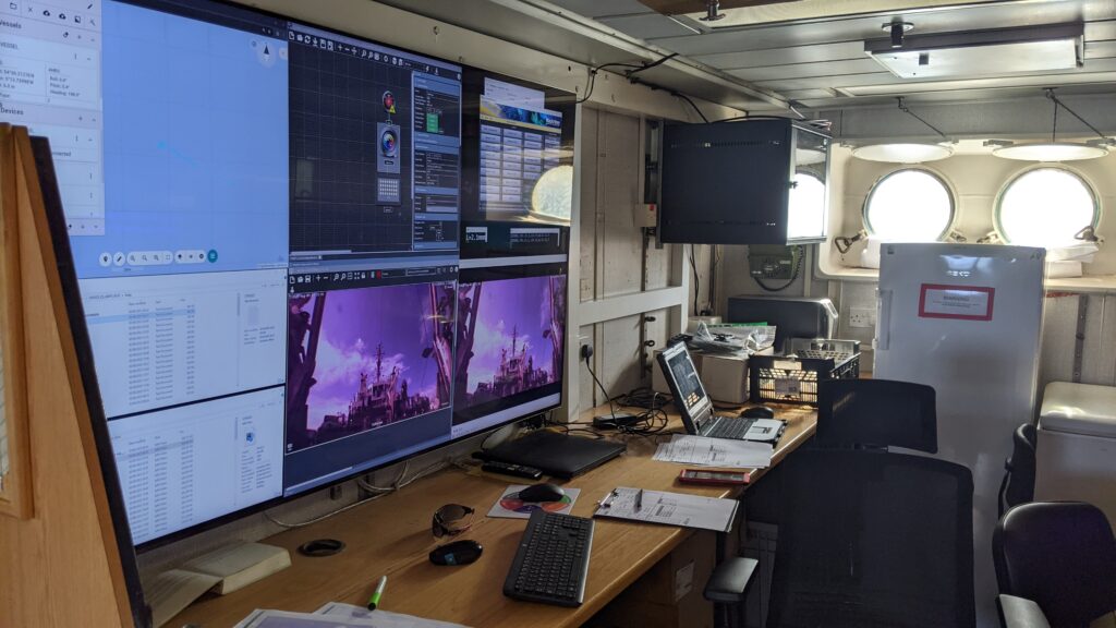
Muddy habitat is ideal for UWTV survey work, as a camera sledge system can be deployed to the seabed, allowing us to obtain very consistent video footage. This is because we can keep the camera on the sledge at a fixed height above the seabed, even if the vessel above is moving around, making it easier to identify and count Nephrops burrows accurately. The camera sledge is fitted with lighting to clearly illuminate the seabed, as well as additional sensors to measure environmental conditions such as water temperature and water clarity. Finally, there is long communication cable, to bring the live video footage to the computers and scientists to observe and record aboard the ship. All this gear makes the sledge relatively heavy, meaning we need a relatively large vessel to deploy and recover the sledge safely.
This is where the RV Corystes comes in as one such vessel. Measuring approximately 53 metres in length and with gross weight of around 1290 tonnes, the RV Corystes was constructed as a state-of-the-art research platform. She is equipped with advanced laboratories, winches, trawl gear, and hydrographic instruments. Her robust design allows for work to continue even in challenging sea conditions, making her suitable for a variety of scientific operations: oceanography, environmental monitoring and, of course, fisheries surveys.
The name "Corystes" is derived from Corystes cassivelaunus, a type of crab found in the North Sea, reflecting her scientific mission. Corystes was built in 1988 by Ferguson Shipbuilders Ltd, located in Port Glasgow, Scotland. Commissioned by the British government for the Ministry of Agriculture, Fisheries and Food (MAFF), later Defra and Cefas, before being transferred to Northern Ireland to be operated by AFBI from 2006. The vessel was designed specifically for research purposes and over the years, she has undergone several refits to update her equipment and to comply with evolving safety standards. Despite her age, these upgrades have ensured she remains at the forefront of marine research.
At start of each of the planned survey locations (stations), the ship’s crew will position the vessel into the prevailing sea current. This is done to ensure maximum manoeuvrability of the ship and clarity of the camera footage being obtained. The sledge is then deployed and towed over the seabed at a fixed speed, recording continuous footage of the seabed and its features. Footage in the Irish Sea can be of variable quality, due to prevailing sea and weather conditions or due to recent fishing activity, all of which can disturb sediments and reduce clarity. For this reason, the footage is checked immediately, to ensure consistent, high-quality data are collected and a survey station may need to be repeated if conditions are not quite right.
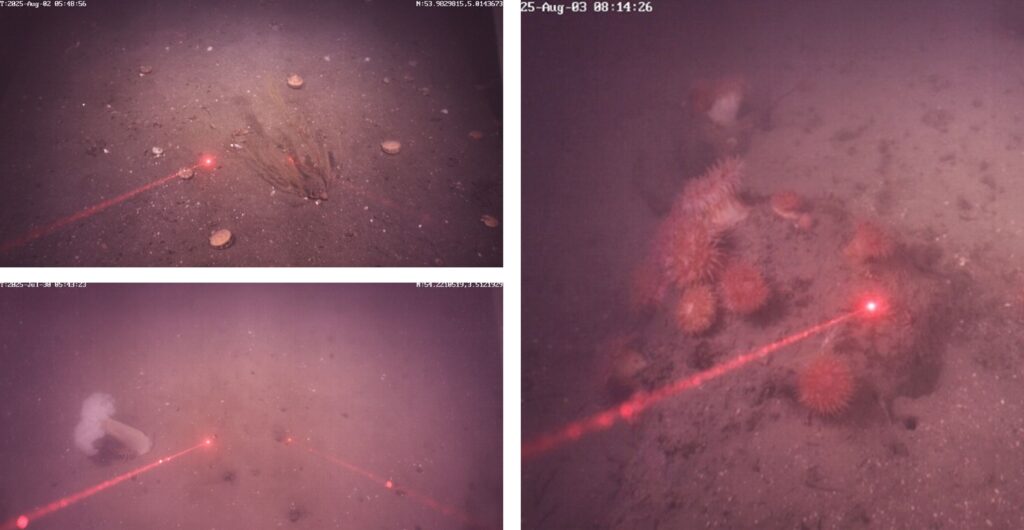
Next, it’s over to the counting teams. Their role is to review all the footage obtained and identify the Nephrops burrows. This process isn’t as simple as it sounds. Firstly, animals other than Nephrops burrow into the sediment. Part of the ‘trick’ to counting is therefore determining which burrows are those of a Nephrops and which belong to other burrowing species. Secondly, a burrow system may have multiple entrances and exits. We don’t want to count a burrow system twice. So, distinguishing which entrances and exits form a single burrow system is very important. Consistent and accurate counting relies heavily on training and experience. Counting teams typically have many years of expertise, and each Nephrops fishing area presents its own subtle differences. To maintain consistency, all counters take part in annual training to ensure that burrows are identified and counted in line with agreed standards for each survey area.
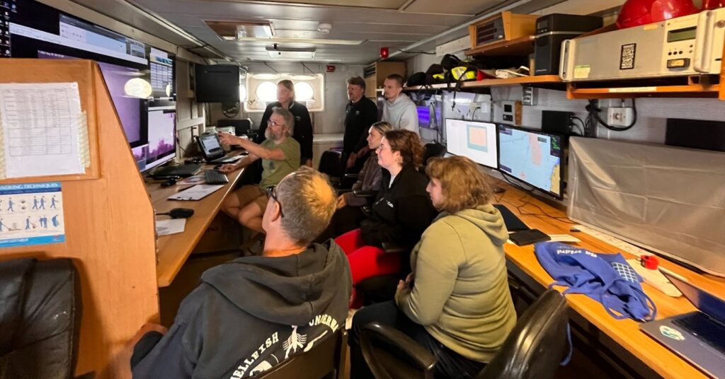
This is where the Corystes survey is quite unique. Here, scientists from the 3 organisations: AFBI, Cefas and MI, are counting as a single cohort, having the opportunity to train and work directly with their international colleagues. As such, counters bring their experience of several other Nephrops surveys and areas to the Corystes and, equally, can take away experience gained back to their own organisations. This increases consistency of counting over the entire Nephrops survey programme across Europe.
Footage is counted at least twice, each time with a different counter. After two counts, we compare the counts obtained. All going well, the counts are quite similar and show general agreement, allowing the station to be ‘passed.’ If not, the footage is examined again, often with a third counter and a process is followed to determine which of the counts can be ‘passed.’ Extra effort may be required for several reasons, for instance where there are many other burrowing species present in the footage, or where visibility is more limited. Where visibility is particularly limited, the counters may request a station to run again.
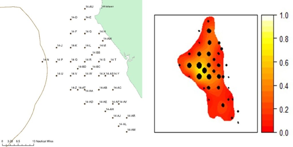
Counting and quality checks are usually all done while at sea. Processing then uses the validated counts, along with station details, to estimate a density of Nephrops burrows at each of the stations.
Further processing combines all the burrow density figures. We can then produce an estimate of the total number of burrows for the entire area. This then directly translates to a total number of adult Nephrops over the area. The entire process is based on internationally agreed methods, published by ICES, in the Manual for Nephrops Underwater TV surveys.
Assessing the results
Survey results are scrutinised further onshore, where they are interpreted in the context of long-term fisheries statistics and our understanding of Nephrops biology and population dynamics. While some natural variation in Nephrops abundance is expected from year to year, large changes uncommon. Where a substantial change is indicated, we revisit the underlying data and analytical steps to ensure that the result is robust and consistent with both the survey evidence, our biological knowledge and the wider body of fisheries data.
All results are presented at two ICES working groups, firstly the Working Group for the Assessment of Nephrops Stocks (WGNEPH) and secondly at the Working Group for Nephrops Surveys (WGNEPS). These groups include scientists from across Europe and both may make recommendations for additional work to be carried out before a survey result is formally accepted. At WGNEPH, the total number of Nephrops obtained from the UWTV survey is combined with an average size of each individual (obtained from port and at-sea sampling) to produce an estimate of stock size. Stock assessors will use this estimate of stock size as a basis for ICES setting catch advice, which will ultimately be used by policy makers in quota setting, negotiated between the EU and UK .
Next steps
Confidence in this method of conducting marine surveys is high, particularly given the level of scrutiny through ICES. Despite technological advancements over the last 30 years, the core UWTV survey methodology has remained largely the same since its inception. Most UWTV surveys remain unchanged for long periods and there is a value to consistency when explaining changes in Nephrops abundance between years. Camera technology continues to evolve and has led to higher quality imagery being collected, making identification (or otherwise) of Nephrops burrow systems more reliable. Focus at the moment is on augmenting the work of counting teams using AI. Machine learning tools can already be used to identify burrow entrances. However, work is underway to identify burrow systems (linking together multiple entrances) as well as to measuring burrow systems. One aim of this work is to eventually train an ‘AI counter’ able to act as a common reference point for current and future counters, In the longer term, we aim to gain better insight into in-year effects on counting, factors influencing burrow excavation and fluctuations in physical factors and how changes in environmental conditions may affect Nephrops behaviour and distribution.
Thanks to colleagues in AFBI and the Marine Institute for their contributions to this blog.