Marine Scientist Michelle Devlin, was one of three Cefas ecology experts sent, at the request of the Mauritian Government, to support the country’s response to a devastating oil spill, after MV Wakashio containing 4,000 tons of fuel ran aground and broke up near environmentally protected coral reefs in July of this year.
Michelle and her colleagues, Dr Sue Ware and Dr Phillipe Bersuder, returned to the UK last month, following work with local experts and communities to help restore its coastline and protect the thousands of animal species at risk of oil pollution. In this blog Michelle reflects on the impact of the oil spill and the role of marine science in mitigating environmental disaster.
Marine biodiversity under threat
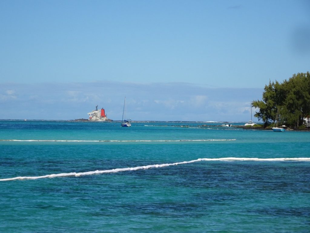
MV Wakashio, a 299m bulk carrier, grounded, on 25 July, on the outer reef about 1.5 nautical miles off the South East coast of Mauritius. Over the time of the ship breaking up, 3,000 tons of fuel oil were removed from the carrier. Unfortunately, complete removal was not possible due to the location of the vessel and weather logistics. On 6 August, the hull of the grounded vessel began to break apart, and low sulphur fuel oil was released into the surrounding marine environment. Mitigation and clean up began immediately, with several booms deployed to stop movement on oil.
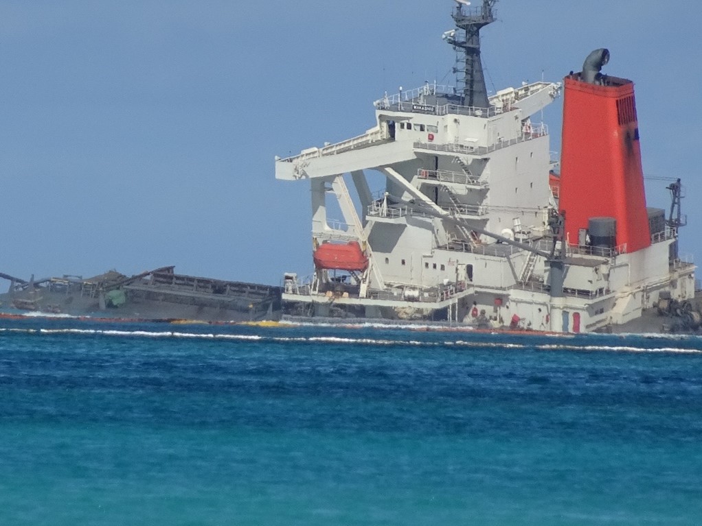
The ship ran aground off Pointe d’Esny and just to the north of Blue Bay Marine Park. These sites are listed under the Ramsar Convention on Wetlands of International Importance as biodiversity hotspots. Fortunately, due to the nature of the prevailing weather conditions at the time of the spill, the vulnerable habitats in the nearby Blue Bay Marine park were largely unaffected in the short term. Blue Bay Marine Park, is a marine protected area, and one of Mauritius’ main tourist attraction. The presence of mangroves, seagrass meadows, and macro algae make it a habitat for about 72 fish species and the endangered green turtle.
Ocean currents carried the oil northwards, avoiding the Blue Bay Marine Park, but the northern coastline, the mangroves on the shoreline north of Pointe d’Esny and the Île aux Aigrettes, a small island near the wreck, were affected in the short term.
UK marine scientists in Mauritius
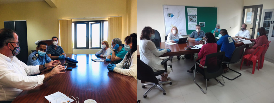
In view of the serious nature of the disaster, my colleagues and I were granted special dispensation to travel in spite of UK travel restrictions and were Covid-secure at all times. Our collective expertise includes oil spill response monitoring, water quality, coral reef and seagrass assessment and marine chemical contamination. We have worked extensively in environmental issues across the UK and internationally, making us well placed to understand the extent and impact of the grounding. Once in country, with the support of the British High Commission (BHC), Foreign Commonwealth and Development Office (FCDO) and UK Aid, we helped the relevant Mauritian government departments and agencies develop an integrated approach to post spill monitoring and assessment applying best scientific practice introduced in the UK Premiam guidelines. Monitoring and assessment will focus on both physical impacts at the casualty site where the stern section of the vessel remains, and also any issues resulting from the entry of oil into the lagoon and coastal areas. The Cefas team will also contribute to a long-term strategy to consider the ecological assets of Mauritius and what remediation and mitigation is required to ensure the coastal ecosystems are protected into the future.
How hazardous is oil?
Oil contains a mixture of hydrocarbons that can impact on the coastal and marine environment. Accidental spills of oil and chemicals into the marine environment have the potential to cause substantial harm to the marine and coastal resources that many in society use and enjoy. Fish, shellfish, and corals may not be exposed immediately, but can come into contact with oil if it is mixed into the water column.
Mangroves are the most sensitive shore-line habitat to oil spill effects. They are slow growing, sensitive to oil, and difficult to clean. They usually grow in low energy environments where oil can persist for years. These areas should receive the highest protection priority during a spill. The impacts on the Mauritius ecosystems need to consider a number of vulnerable habitats including coral reefs, seagrass bed, mangroves and the water column. Concern over the longer-term impacts on human, environmental and food safety also needs to be considered.
A local and international response
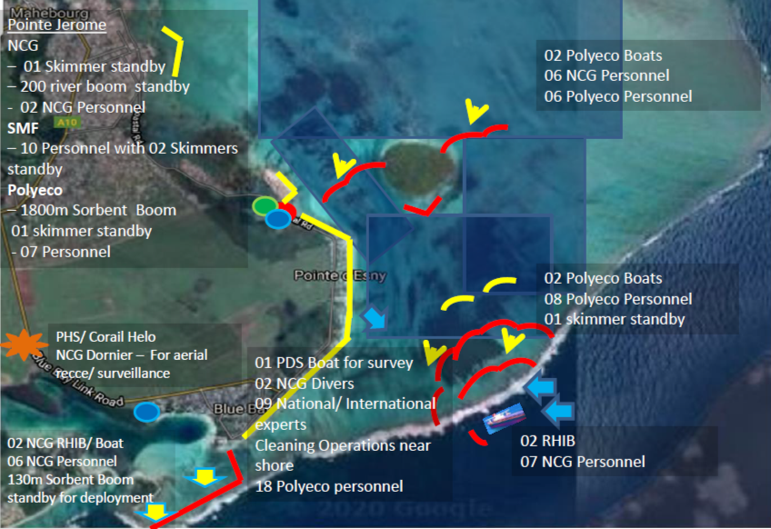
In the vicinity of the grounded site, there is Ile aux Aigrettes islet, the Blue Bay Marine Park and Pointe d’Esny Wetland, all areas which are important to biodiversity. Mauritius communities live and work within the impacted areas, relying on them for their livelihoods, through tourism and fishing. The communities have been a part of the clean-up and are also directly affected by many aspects of the oil spill. Immediately following the spill, a number of measures were put in place to assist in containing the released oil and, as far as possible, to prevent and or reduce damage to the environment and conservation areas adjacent to the spill. These included an incredible response from the local community with thousands of Mauritian nationals and expatriates gathering to make artisan booms to protect their coastal resources. Booms are floating, physical barriers to oil, made of plastic, metal, or other materials, which slow the spread of oil and keep it contained. Professional bodies also worked alongside local communities to place booms as part of a multiple set of measures to restrict and reduce the spread of the oil on to the vulnerable coastal systems and protect the sites with high biodiversity.
Footprint of impact
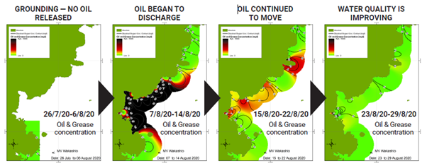
Mapping the extent of the oil spill identifies the areas that are impacted by the oil. A number of modelling approaches have been applied to help estimate the footprint of oil released from the grounded vessel. Identification of the extent and severity of shoreline impacts resulting from the released oil can be informed by modelling the extent of the oil and the possible consequences of its impact. The modelling is validated by using information from the monitoring program and satellite images.
Modelling and mapping of the movement of the oil spill has provided information on the extent and duration of the oil on the coastal communities and marine environment. Knowledge of where the oil has gone informs the clean-up action and will identify areas of high risk, where long term monitoring and mitigation actions will be required.
The Long-Term Monitoring Plan
It is easy to see the oil spill and the dark plume of oil that has reached some of the important coastal environments of Mauritius. However, it is not just the visible part of the oil spill that requires assessment. Longer-term monitoring is required to understand and mitigate the ongoing effects of the oil spill. Many agencies are working together in the aftermath of the spill to monitor and assess the short-term impacts of the oils spill. These agencies will continue to collaborate to understand the human and environmental impacts of the oil spill
Following the grounding of the MV Wakashio, and the subsequent oil spill, a number of local and international expert groups collaborated to develop an integrated monitoring plan. These experts, with ourselves included National Environment Laboratory (NEL), Mauritius Oceanography Institute (MOI), Albion Fisheries Research Centre (AFRC), University of Mauritius, Japanese Disaster Relief (JDR), National Coast Guard (NCG), Reef Conservation, Mauritian Wildlife Foundation (MWF), Eco-Sud, International Tanker Owners Pollution Federation (ITOPF) and the Commonwealth Secretariat.
Monitoring and assessment priorities are the:
- impacts arising from physical damage to the reef habitats at the wreck site
- physical impacts arising from the booms and their associated ropes and chains used for anchorage
- impacts caused by the sediment plume arising as a result of the movement of the wreck against the reef on which it rests
- impacts on environmental quality and contamination resulting from the leaked oil (e.g., coastal, offshore and subtidal habitats, water, sediment and biota)
- public health and food safety concerns (e.g., where harvestable resources may have come into contact with the spilled oil).
Hope for the future
The integrated post spill monitoring framework will help to understand the ongoing impact of the oils spill. The international response working alongside Mauritius agencies has been able to determine the footprint of the impacted areas and types of habitats affected. The monitoring will consider the fate and recovery of those impacted ecosystems and identify the area of risk, both in terms of location and time. Ongoing monitoring will be carried out via the Mauritius agencies and the information will be used to regularly assess how the recovery is tracking.
Emergency response to oil spills can be challenging in the best of circumstances and, in the case of the Mauritius oil spill this was further hampered by restrictions implemented to mitigate against COVID19. None the less, expert teams from the UK (supported by UK Aid), Japan, France and India contributed to the emergency response. Immediate response, ahead of our arrival, naturally focused on clean-up efforts with our main contribution being the development of an integrated environmental monitoring programme (IEMP) which would feed into a robust impact assessment and provide recommendations for restoration as required.
Looking forward, collaborations continue, albeit remotely, to finalise the plan for implementation. Once implemented, it is intended that the Mauritius and international experts will ‘meet’ on a quarterly basis to report back the results and outcomes of monitoring and allow the monitoring plans to be adapted accordingly. Much has been done, much needs to be done, but with regular monitoring and targeted mitigation and recovery actions, I am hopeful that the unique and important coastal and marine ecosystems will recover over time.